Ruta 040
Hola, ha pasado bastante tiempo desde la ultima publicación. Por eso, queremos llegar por todo lo alto y que mejor que contaros la ruta que subes del mar al cielo.
Os dejamos toda la información facilitada por Turismo de Tenerife, y al final os dejamos todas la direcciones.
Que mejor plan que hacer senderismo y luego descansar en Gara Hotel.
040, la ruta de mayor desnivel de España
La Ruta 040, que se inaugura este 2020 tras un periodo de completa rehabilitación, es el recorrido de mayor desnivel de España, lo que lo convierte en un icono de los trazados a nivel nacional —además de estar entre los de mayor desnivel de Europa—. El hecho de que se pueda completar en una sola jornada, y de que su trazado promueva la recuperación de antiguos caminos en desuso o abandono, hacen de él uno de los recorridos más atractivos de todo el país.
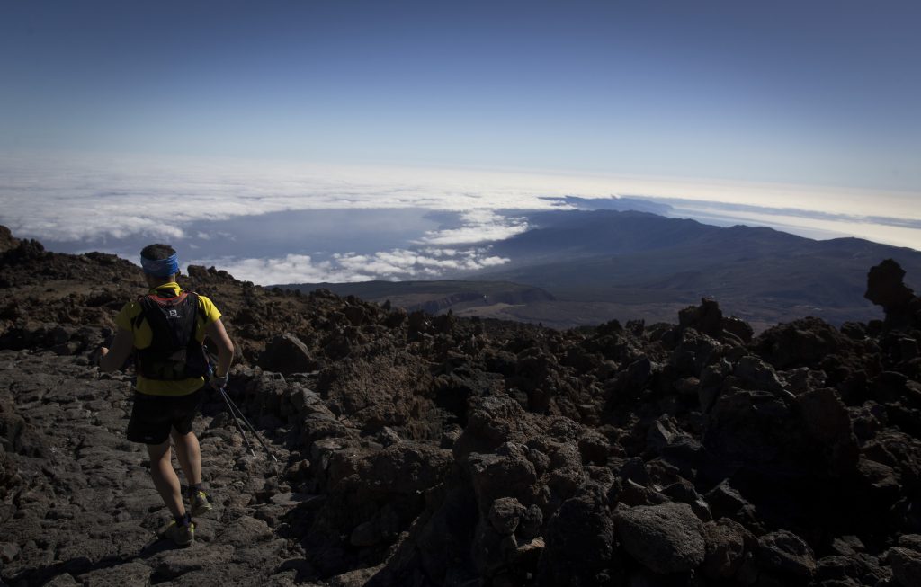
Habitualmente utilizado por deportistas de élite para su entrenamiento, además de por aficionados, su recorrido se inicia en la misma playa del Socorro, para culminar en el mismo pico del Teide, y volver a bajar (aunque cada usuario puede hacerla como desee según su nivel). Ofrece la opción, justo antes de llegar a Montaña Blanca, en el mismo Parque Nacional, de continuar por el sendero de pequeño recorrido con el que conecta y que lleva al Centro de Visitantes del Portillo.
Es ideal tanto para realizar caminando, lo que permite completarlo entre en una media de 12 horas, o corriendo, lo que reduce su duración a unas 4-6 horas.
La historia de su denominación proviene de un grupo de montañeros locales, que querían dar visibilidad a diferentes rutas en cada una de las Islas Canarias que partieran del mar hasta su respectiva cumbre más alta y regresaran de nuevo al mar. A la primera isla le tocó 0-1-0, a la segunda 0-2-0… y a Tenerife el 4, de ahí lo de 0-4-0, que casualmente responde a las especiales características de su recorrido, ya que parte desde el nivel del mar para ascender hasta los casi 4.000 metros de altitud del Pico del Teide y regresar de nuevo al punto de partida.
Proceso de rehabilitación
El proyecto de rehabilitación de la Ruta 040, desarrollado durante los últimos años, ha consistido en la adecuación de la señalización, del estado del sendero y de su seguridad. La iniciativa ha contado con la participación del Ayuntamiento de los Realejos, Turismo de Tenerife y las áreas de Medio Ambiente, de Turismo y de Carreteras del Cabildo Insular de Tenerife, además del Consejo Insular de Aguas, el Parque Nacional del Teide, el Organismo Autónomo de Parques Nacionales y la Federación Tinerfeña de Montañismo.
Los objetivos perseguidos con esta acción han sido:
- Crear una ruta de senderismo que una el nivel del mar de Tenerife con su cota a mayor altitud, en este caso la cima del Teide (se divide en dos tramos para poder homologarla ERA, como se explica en la ficha).
- Dar identidad, mediante señalización, información y divulgación a un itinerario de subida al Teide desde el nivel del mar lleva varios años siendo muy utilizado por senderistas locales y foráneos, y que une la Playa del Socorro con la cima del citado volcán.
- Crear un sendero a homologar, y por lo tanto a incluir dentro de la Red Canaria de Senderos, que discurra entre la Playa de El Socorro y El Portillo.
- Mejorar la calidad de tránsito de senderistas por un itinerario muy frecuentado en los últimos años.
- Realizar las actuaciones necesarias para aumentar la seguridad del senderista, sobre todo en aquellos tramos en los que se discurra por carretera, pista o calle.
- Conectar esta ruta con la red de senderos del Parque Nacional del Teide.
- Recuperación de antiguos caminos actualmente en desuso o abandono.
El recorrido
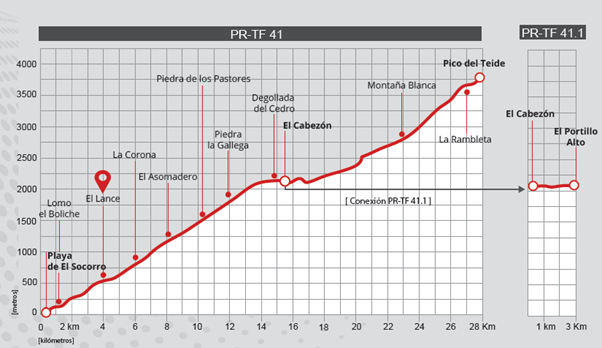
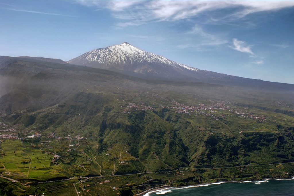
Con una longitud total cercana a los 30 kilómetros hasta el Pico del Teide (27.762 metros), y de 53 kilómetros cuando se completa el recorrido de bajada, la Ruta 040 transcurre principalmente por el municipio de Los Realejos, aunque también se adentra en el de La Orotava. Durante su trazado recorre los espacios naturales del Paisaje Protegido de Los Campeches, Tigaiga y Ruiz, el Parque de la Corona Forestal y el Parque Nacional del Teide, para regresar de nuevo, en un recorrido inverso, hasta la costa.
Su punto de inicio se sitúa en los 12 metros sobre el nivel del mar para acabar en los 3.718 metros del pico del Teide, el punto más alto de España, lo que hace que su desnivel se sitúe por encima de los 3.600 metros, un hito único en todo el territorio nacional.
Datos técnicos
Sendero PR-TF 41: Playa de El Socorro – Pico del Teide
Inicio: Playa del Socorro
Punto intermedio: Pico del Teide
Fin: Playa del Socorro
Estado de homologación: Prehomologado
Grado de dificultad: Muy alta
Tipo de recorrido: Lineal
Distancia: 26.5Km cada tramo (56 km en total si se completa también la bajada).
Duración: Aproximadamente, entre 7 y 9 horas caminando o de 4 a 6 horas corriendo.
Altura máxima: 3718 m
Altura mínima: 0 m
Desnivel acumulado de ascenso: 4000 m
Desnivel acumulado de descenso: 4000 m
Conexiones con otros senderos:
PT-TF 40 Ladera de Tigaiga
PR-TF 41.1 El Cabezón – El Portillo Alto.
7. Montaña Blanca – Pico del Teide
10. Acceso cráter del Pico del Teide. Sendero Telesforo Bravo
11. Mirador de La Fortaleza
Espacios Naturales Protegidos:
Paisaje Protegido Los Campeches, Tigaiga y Ruiz
Parque Natural de Corona Forestal
Parque Nacional del Teide
Autorización necesaria: Sí, a partir de La Rambleta para acceder al sendero número 10 Telesforo Bravo y coronar el Pico del Teide. Para ello, es necesario realizar la reserva en el siguiente enlace: https://www.reservasparquesnacionales.es/real/parquesnac/usu/html/detalle-actividad-oapn.aspx?cen=2&act=1
Descripción técnica del recorrido: Comienza en la playa de El Socorro, en Los Realejos, y coincide con el sendero PR-TF 41. Los primeros kilómetros atraviesan un entorno de carácter rural y las laderas del paisaje protegido Los Campeches, Tigaiga y Ruiz. Un fuerte repecho lleva hasta el mirador de la Corona y, poco después, al del Asomadero. A partir de allí, la alfombra de monte del parque natural de Corona Forestal es protagonista.
Ya en el ecuador vertical, el pinar da paso al matorral de alta montaña del Parque Nacional del Teide. Al llegar al entorno de la montaña del Cabezón, se puede optar por la derivación PR-TF 41.1 hasta el Portillo Alto o por el serpenteante ascenso hasta La Rambleta (3555 m). Hasta este punto se puede llegar libremente, pero para recorrer los últimos 630 metros y coronar el Pico del Teide es necesario disponer de un permiso que se solicita con antelación en la web www.reservasparquesnacionales.es.
Altimetría:
Tenerife, un paraíso para la práctica de actividades al aire libre
La Ruta 040 es la muestra de que Tenerife es un destino idóneo para la práctica de una gran variedad de deportes y actividades de ocio: la Isla como gimnasio al aire libre abierto 365 días al año.
El clima, sus paisajes y espacios naturales o sus infraestructuras de primer nivel convierten a Tenerife en un auténtico paraíso para la práctica de toda clase de actividades físicas y deportivas al aire libre tanto para equipos profesionales como para amateurs y aficionados. En apenas media hora, el usuario puede pasar de entrenar a nivel del mar a hacerlo a 2.000 metros de altitud, con un Parque Nacional del Teide que permite acostumbrar el organismo a grandes esfuerzos (es lo que hacen, por ejemplo, los más destacados equipos ciclistas que compiten en el Tour de Francia), o deleitarse con un paisaje sublime mientras se practica la actividad física favorita, desde senderismo a mountain bike, pasando por windsurf, kitesurf, parapente o buceo.
Más informacion:
https://www.webtenerife.com/tenerifenolimits/
Facebook:
Twitter:
Youtube
Youtube: https://youtu.be/DsRlQS4of3U
Hi, it’s been a while since the last post. That’s why we want to get all the way up high and what better to tell you the route you go up from the sea to the sky
We leave you all the information provided by Turismo de Tenerife, and at the end we leave you all the addresses.
What better plan than hiking and then relaxing at Gara Hotel.
040, the most challenging route in Spain
Route 040, which is reopening in 2020 after a period of upgrade work, is the most challenging route in Spain in terms of elevation gain, making it an iconic route at a national level as well as being among the toughest in Europe. The fact that it can be completed in a single day, and that it involves the recovery of previously disused or abandoned paths, makes it one of the one of the most attractive routes in the whole country.
Often used by elite athletes for their training, as well as by enthusiasts, the route starts at El Socorro beach and culminates in the summit of Mount Teide, then descends again (although every individual can do it how they prefer to, depending on their level). It offers the option, just before reaching Montaña Blanca within the National Park itself, of continuing along a short connecting trail that leads to the El Portillo Visitor Centre.
It is perfect for hiking, meaning that it can be completed in an average of 12 hours, or running, reducing its duration to about 4-6 hours.
The story of its name comes from a group of local mountaineers, who wanted to give greater visibility to different routes on each of the Canary Islands, all of which begin at the sea, go as far as their respective highest peak, and then return to the sea. The first island was given 0-1-0, the second 0-2-0, and so on. Tenerife was the fourth, hence 0-4-0, which as it happens is a nod to the special characteristics of its route, since it starts at sea level and ascends to the almost 4,000 metre altitude of Mount Teide before returning to the start point again.
Upgrading the route
Work to upgrade Route 040, which has been undertaken over recent years, has consisted of improving signage, the state of the trail and its safety. Several organisations have been involved in the initiative, including the Los Realejos Town Council, the Tenerife Tourism Corporation and the Environment, Tourism and Highways departments of the Tenerife Island Council, as well as the Island Water Board, the Teide National Park, the Autonomous Authority for National Parks and the Tenerife Mountaineering Federation.
The objectives of this project were as follows:
- To create a hiking route that would join Tenerife’s sea level with its highest altitude point, in this case the summit of Mount Teide (which is divided into two sections for authorisation purposes, as explained in the technical information).
- To give identity, through signage, information and promotion, to a way of climbing the Teide from sea level that for many years has been heavily used by local and foreign hikers, connecting El Socorro beach with the summit of the volcano.
- To create a path that would be given approval, and therefore be included within the Canary Islands Network of Trails, running between El Socorro beach and El Portillo.
- To improve walkers’ experience of a route that has been very popular in recent years.
- To take the necessary steps to increase the safety of hikers, especially on those sections where it runs along a road, track or street.
- To connect this route with the trail network of Mount Teide National Park.
- To recover old routes that had fallen into disuse or been abandoned.
The route
With a total length of almost 30 kilometres (27,762 metres) to the Peak of the Teide, and 53 kilometres when the descent is completed, Route 040 mainly covers the municipality of Los Realejos, although it also enters that of La Orotava. The route passes through several natural spaces, including Los Campeches, Tigaiga and Ruiz Protected Landscape, Corona Forest Natural Park and Mount Teide National Park, to then return via the reverse route to the coast.
Its starting point is at 12 metres above sea level and it ends at 3,718 metres at the summit of Mount Teide, the highest point in Spain, which makes its elevation gain over 3,600 metres. It is a unique national landmark.
Technical data
Trail PR-TF 41: El Socorro Beach – Summit of Mount Teide
Start: El Socorro beach
Halfway point: Summit of Mount Teide
End: El Socorro beach
Approval status: Pre-approved
Degree of difficulty: Very high
Type of route: Linear
Distance: 53 km if ascending and descending. Each section is 26.5 km
Duration: Approximately 7-9 hours walking or 4-6 hours running.
Maximum height: 3,718 m
Minimum height: 0 m
Cumulative elevation gain (ascent): 4,000 m
Cumulative elevation loss (descent): 4,000 m
Connections with other paths:
PT-TF 40 Ladera de Tigaiga
PR-TF 41.1 El Cabezón – El Portillo Alto.
7. Montaña Blanca – Mount Teide
10. Access to Mount Teide crater. Telesforo Bravo Path
11. La Fortaleza Viewpoint
Protected Natural Spaces:
Los Campeches, Tigaiga and Ruiz Protected Landscape
Coronal Forest Natural Park
Mount Teide National Park
Authorisation required: Yes, after La Rambleta to access Path No. 10 Telesforo Bravo and to reach the summit of Mount Teide. To do this, you need to make a booking on the following website: https://www.reservasparquesnacionales.es/real/ParquesNac/index.aspx?ii=6ENG
Technical description of the route: It starts at El Socorro beach, in Los Realejos, and coincides with the PR-TF 41. The first few kilometres cross a rural environment and the slopes of the Los Campeches, Tigaiga and Ruiz protected landscape. A steep climb leads to the La Corona viewpoint and, shortly after, to the El Asomadero viewpoint. From there on, the mountain brush of the Corona Forest Natural Park is at the fore.
Half way up our ascent, the pine forest gives way to the high mountain scrub of Mount Teide National Park. As you approach El Cabezón Mountain, you can opt for the PR-TF 41.1 path to Portillo Alto or for the winding ascent up La Rambleta (3555 m). This point can be reached without needing a permit, but to climb the last 630 metres and reach the summit of Mount Teide you will need to have a permit, which can be requested in advance on the website
Altimetry:

Tenerife, a paradise for outdoor activities
Route 040 is proof that Tenerife is an ideal destination for a wide variety of sports and leisure activities – the Island is an open-air gym, open 365 days a year.
The climate, its landscapes and natural spaces, and its first-rate infrastructures make Tenerife a real paradise for all kinds of outdoor physical and sports activities, for both professional teams and amateurs or aficionados. In just half an hour, visitors can move from training at sea level to doing so at an altitude of 2,000 metres. Mount Teide National Park lets your body become accustomed to hard physical activity (this, for example, is what the most outstanding cycling teams training for the Tour de France do), or allows you to enjoy a sublime landscape while practising your favourite physical activity, from hiking to mountain biking, windsurf, kite surf, paragliding and scuba diving.
More Information:
https://www.webtenerife.com/tenerifenolimits/
Facebook:
Twitter:
Youtube
Youtube: https://youtu.be/DsRlQS4of3U